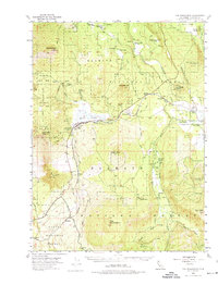
1954 Map of The Whaleback
USGS Topo · Published 1974About this map
Grass Lake and the high peaks of the eastern Klamath range dominate this mid-century survey of Siskiyou County. The landscape is defined by its industrial timber and transit infrastructure, where the Southern Pacific railroad parallels the main highway through the valley floor. Small outposts and labor sites like Penoyar, Leaf Camp, and the Hoffman Mill (Site) reflect the era's reliance on rail for moving timber from the surrounding Klamath National Forest.
Find a feature on this map
61 named features on this map. Tap any name to fly to it.
Don’t see what you’re looking for? This feature index may not catch every label — zoom into the map to look around manually.
Map Details
Editions of this 1954 The Whaleback Map
3 editions found

Other maps of this area

1886 · Modoc Lava Bed
USGS Topo · 1:250,000

1886 · Shasta
USGS Topo · 1:250,000

1892 · Modoc Lava-Bed
USGS Topo · 1:250,000

1894 · Shasta
USGS Topo · 1:250,000

1922 · Shasta Valley Sheet No 10 E
USGS Topo · 1:24,000

1932 · Bartle
USGS Topo · 1:96,000

1934 · Macdoel
USGS Topo · 1:96,000

1935 · Dunsmuir
USGS Topo · 1:125,000

1939 · Bartle
USGS Topo · 1:125,000

1941 · Macdoel
USGS Topo · 1:125,000