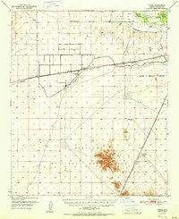
1951 Map of Theba
USGS Topo · Published 1951About this map
The Southern Pacific railroad cuts through this arid landscape, anchoring the settlement of Theba and the siding at Smurr. Agriculture in this desert environment is sustained by the Gila Bend Canal and various Irrigation Canals pulling from the Gila River. The presence of the Gillespie Ranch and the nearby private Gillespie Airfield indicates a significant localized footprint of ranching and aviation infrastructure in the early postwar years.
Find a feature on this map
30 named features on this map. Tap any name to fly to it.
Don’t see what you’re looking for? This feature index may not catch every label — zoom into the map to look around manually.
Map Details
Editions of this 1951 Theba Map
2 editions found
Other maps of this area

1942 · Vicksburg
USGS Topo · 1:250,000

1949 · Sentinel
USGS Topo · 1:62,500

1950 · Sentinel
USGS Topo · 1:62,500

1950 · Theba
USGS Topo · 1:62,500

1951 · Gila Bend
USGS Topo · 1:62,500

1951 · Theba
USGS Topo · 1:62,500

1951 · Dendora Valley
USGS Topo · 1:62,500

1951 · Cotton Center
USGS Topo · 1:62,500

1951 · Woolsey Peak
USGS Topo · 1:62,500

1953 · Ajo
USGS Topo · 1:250,000