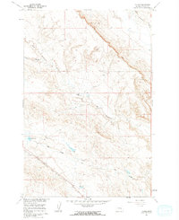
1960 Map of Thebes
USGS Topo · Published 1962About this map
The Chicago Milwaukee St Paul and Pacific railroad cuts a diagonal path through this Montana landscape, serving as a primary corridor for movement across Rosebud County. Near the southern end of the rail line lies the small settlement of Thebes, positioned just west of the drainage from Sun Coulee. This area is defined by a series of narrow coulees and creek beds that feed into larger water bodies, including Great Porcupine Creek in the northeast and Thebes Lake near the townsite.
Find a feature on this map
8 named features on this map. Tap any name to fly to it.
Don’t see what you’re looking for? This feature index may not catch every label — zoom into the map to look around manually.
Map Details
Editions of this 1960 Thebes Map
2 editions found
Other maps of this area

1954 · Forsyth
USGS Topo · 1:250,000

1957 · Forsyth
USGS Topo · 1:250,000

1958 · Forsyth
USGS Topo · 1:250,000

1960 · Steie Ranch
USGS Topo · 1:24,000

1960 · Hagen Ranch
USGS Topo · 1:24,000

1960 · Vananda
USGS Topo · 1:24,000

1960 · Ahles
USGS Topo · 1:24,000

1960 · Thebes
USGS Topo · 1:24,000

1960 · Ingomar East
USGS Topo · 1:24,000

1960 · Brown Coulee
USGS Topo · 1:24,000