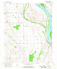
1967 Map of Thebes SW
USGS Topo · Published 1968About this map
The Mississippi River dominates this landscape along the Missouri-Illinois border, where a complex network of chutes and islands reflects the shifting nature of the river before modern stabilization. Large landmasses like Powers Island and Billings Island are separated from the mainland by narrow passages such as Santa Fe Chute and Doolan Chute. On the Missouri side, the townships of Commerce, Moreland, and Tywappity are defined by an extensive drainage system including North Cut Ditch and Brushy Ditch, illustrating the mid-century transformation of the floodplain for agricultural use. Small rural hubs are anchored by local landmarks such as Price Landing and the Thomas W Kelly School. Genealogists may find value in the scattered burial grounds, including Prince Cem, Pollard Cem, and Cason Cem, which serve as quiet markers of the area's early settlement history.
Find a feature on this map
31 named features on this map. Tap any name to fly to it.
Don’t see what you’re looking for? This feature index may not catch every label — zoom into the map to look around manually.
Map Details
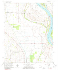
Editions of this 1967 Thebes SW Map
2 editions found
Other maps of this area

1931 · Sikeston
USGS Topo · 1:62,500

1934 · Thebes
USGS Topo · 1:62,500

1934 · Morley
USGS Topo · 1:62,500

1934 · Sikeston
USGS Topo · 1:62,500

1939 · Sikeston
USGS Topo · 1:62,500

1939 · Charleston
USGS Topo · 1:62,500

1939 · Morley
USGS Topo · 1:62,500

1939 · Thebes
USGS Topo · 1:62,500

1949 · Paducah
USGS Topo · 1:250,000

1950 · Paducah
USGS Topo · 1:250,000