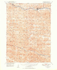
1950 Map of Thedford
USGS Topo · Published 1950About this map
Thedford serves as a central hub for the Nebraska Sandhills in this mid-century survey, situated along the Middle Loup River. The area is defined by the logistical corridor of the Chicago Burlington and Quincy railroad, which parallels the river and connects the village to the settlement of Norway in the northwest. This transportation network was vital for the ranching economy and the local movement of goods through the expansive Thomas County landscape.
Find a feature on this map
15 named features on this map. Tap any name to fly to it.
Don’t see what you’re looking for? This feature index may not catch every label — zoom into the map to look around manually.
Map Details
Editions of this 1950 Thedford Map
2 editions found
Other maps of this area

1948 · Seneca
USGS Topo · 1:62,500

1948 · Thedford
USGS Topo · 1:62,500

1948 · Halsey
USGS Topo · 1:62,500

1948 · Seneca 4
USGS Topo · 1:62,500

1949 · Seneca 4
USGS Topo · 1:62,500

1949 · Purdum
USGS Topo · 1:62,500

1949 · Cody Lake
USGS Topo · 1:62,500

1950 · Thedford
USGS Topo · 1:62,500

1950 · Halsey
USGS Topo · 1:62,500

1950 · Shimmins Lake
USGS Topo · 1:62,500