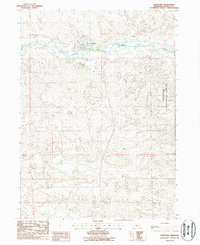
1986 Map of Thedford
USGS Topo · Published 1987About this map
Thedford serves as the central hub of this Sandhills landscape, situated along the valley of the Middle Loup River. The map shows a classic Nebraska rail-and-river town layout, where the community is gathered north of the water while the Hillcrest Cem is placed on higher ground to the south. Further south and east, the terrain transitions into the protected dunes of the Nebraska National Forest, illustrating the deliberate land management of this era. Civic life is well-documented through the presence of the Fairground and County Airport on the town's eastern edge. A small Foot Bridge crosses the river, suggesting the local connections between the town center and the surrounding hills during the mid-1980s.
Find a feature on this map
11 named features on this map. Tap any name to fly to it.
Don’t see what you’re looking for? This feature index may not catch every label — zoom into the map to look around manually.
Map Details
Editions of this 1986 Thedford Map
This is the sole edition of this map. No revisions or reprints were ever made.
Other maps of this area

1948 · Thedford
USGS Topo · 1:62,500

1948 · Halsey
USGS Topo · 1:62,500

1948 · Seneca 4
USGS Topo · 1:62,500

1949 · Seneca 4
USGS Topo · 1:62,500

1949 · Purdum
USGS Topo · 1:62,500

1950 · Thedford
USGS Topo · 1:62,500

1950 · Halsey
USGS Topo · 1:62,500

1951 · Purdum
USGS Topo · 1:62,500

1954 · North Platte
USGS Topo · 1:250,000

1956 · North Platte
USGS Topo · 1:250,000