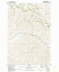
1981 Map of Thera
USGS Topo · Published 1981About this map
Palouse River meanders sharply through the northern portion of this landscape, its steep bends connected by historic crossings like Matlock Bridge and Torrence Bridge. The agricultural character of Whitman County is clearly defined here, centered on the small siding of Thera where Grain Elevators stand alongside the Union Pacific railroad line. This rail corridor follows the natural path of Rebel Flat Creek through the Rebel Flat terrain, illustrating how early transportation infrastructure was dictated by the region's topography.
Find a feature on this map
18 named features on this map. Tap any name to fly to it.
Don’t see what you’re looking for? This feature index may not catch every label — zoom into the map to look around manually.
Map Details
Editions of this 1981 Thera Map
This is the sole edition of this map. No revisions or reprints were ever made.
Other maps of this area

1903 · Oakesdale
USGS Topo · 1:125,000

1905 · Oakesdale
USGS Topo · 1:125,000

1910 · Pullman
USGS Topo · 1:125,000

1950 · Endicott
USGS Topo · 1:62,500

1955 · Pullman
USGS Topo · 1:250,000

1955 · Spokane
USGS Topo · 1:250,000

1958 · Spokane
USGS Topo · 1:250,000

1958 · Pullman
USGS Topo · 1:250,000

1964 · Diamond
USGS Topo · 1:24,000

1964 · St. John
USGS Topo · 1:24,000