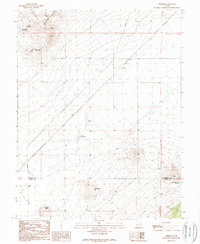
1989 Map of Thermo
USGS Topo · Published 1989About this map
Thermo sits at the heart of this landscape where the Union Pacific railroad cuts through the high desert of the Great Basin. This 1989 provisional study captures the area's distinctive geothermal and hydrological character, centered on the Thermo Hot Springs and several scattered Springs. The terrain transitions from the elevations of the Shauntie Hills and Dead Horse Point in the northwest down toward the basin floor, where the border between Beaver Co and Iron Co is clearly delineated. Human activity in this arid environment is evidenced by the presence of a Gravel Pit, a network of ditches, and various water management features like the Dead Horse Reservoir and Monument Knolls Reservoir. The map provides a detailed look at the infrastructure required to support life and transportation in this part of southwestern Utah during the late twentieth century.
Find a feature on this map
17 named features on this map. Tap any name to fly to it.
Don’t see what you’re looking for? This feature index may not catch every label — zoom into the map to look around manually.
Map Details
Editions of this 1989 Thermo Map
This is the sole edition of this map. No revisions or reprints were ever made.
Other maps of this area

1953 · Ninemile Knoll
USGS Topo · 1:24,000

1953 · Milford Flat
USGS Topo · 1:24,000

1953 · Richfield
USGS Topo · 1:250,000

1958 · Richfield
USGS Topo · 1:250,000

1958 · Thermo
USGS Topo · 1:62,500

1958 · Milford
USGS Topo · 1:62,500

1959 · Frisco
USGS Topo · 1:62,500
1971 · Burns Knoll
USGS Topo · 1:24,000
1971 · Latimer
USGS Topo · 1:24,000

1980 · Wah Wah Mts. South
USGS Topo · 1:100,000