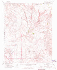
1966 Map of Thirsty Canyon
USGS Topo · Published 1967About this map
Pahute Mesa and Timber Mountain dominate this mid-century landscape within the Nellis Air Force Range, a region defined by high desert plateau and deep incisions like Thirsty Canyon. Traces of earlier transportation and ephemeral habitation appear across the terrain, notably the Las Vegas and Tonopah Railroad Grade cutting through the southwest. The presence of Oasis Springs and the Amargosa River in the Oasis Valley highlights the critical role of water in this arid environment, supporting the vicinity near the Camp Transvaal (Site). Produced in cooperation with the Atomic Energy Commission, the survey details a restricted landscape marked by a Military Reservation Boundary, remote prospects, and a solitary landing strip, capturing the intersection of early mining-era remnants and Cold War military operations.
Find a feature on this map
23 named features on this map. Tap any name to fly to it.
Don’t see what you’re looking for? This feature index may not catch every label — zoom into the map to look around manually.
Map Details
Editions of this 1966 Thirsty Canyon Map
2 editions found
Other maps of this area

1908 · Kawich
USGS Topo · 1:250,000

1908 · Furnace Creek
USGS Topo · 1:250,000

1910 · Furnace Creek
USGS Topo · 1:250,000

1942 · Tolicha Peak
USGS Topo · 1:125,000

1942 · Wheelbarrow Peak
USGS Topo · 1:125,000

1942 · Skull Mountain
USGS Topo · 1:125,000

1942 · Bullfrog
USGS Topo · 1:125,000

1948 · Death Valley
USGS Topo · 1:250,000

1952 · Topopah Spring
USGS Topo · 1:62,500

1952 · Timber Mountain
USGS Topo · 1:62,500