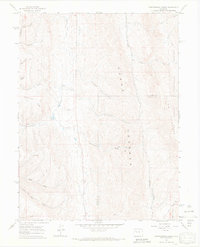
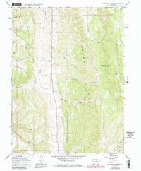
1966 Map of Thirteenmile Creek
USGS Topo · Published 1969About this map
Grand Hogback dominates the central topography of this mid-century survey, forming a distinct geological spine through the northwestern Colorado wilderness. The landscape is defined by an intricate network of drainage basins including Thirteenmile Creek, Fourteenmile Creek, and Twelvemile Creek, all flowing through the White River National Forest. Human impact is visible through specialized land use, particularly the Stock Driveway in the southeast corner near Piceance Creek, reflecting the region's ranching heritage. Several named gulches like Moonlight and Camp Gulch cut through Corral Ridge, while various gravel pits and a network of Jeep Trails and Pack Trails suggest a territory shaped by resource extraction and remote access. The boundary between Rio Blanco and Garfield counties bisects the southern portion of the sheet, providing a precise reference for historical land ownership and administrative limits.
Find a feature on this map
23 named features on this map. Tap any name to fly to it.
Don’t see what you’re looking for? This feature index may not catch every label — zoom into the map to look around manually.
Map Details
Editions of this 1966 Thirteenmile Creek Map
5 editions found
Other maps of this area

1906 · Grand Hogback
USGS Topo · 1:125,000

1910 · Grand Hogback
USGS Topo · 1:125,000

1925 · Parachute Creek
USGS Topo · 1:62,500

1927 · Parachute Creek
USGS Topo · 1:62,500

1952 · Rio Blanco
USGS Topo · 1:24,000

1952 · Horse Mountain
USGS Topo · 1:24,000

1952 · No Name Ridge
USGS Topo · 1:24,000

1952 · Segar Mountain
USGS Topo · 1:24,000

1956 · Grand Junction
USGS Topo · 1:250,000

1957 · Leadville
USGS Topo · 1:250,000