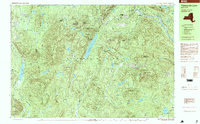
1997 Map of Thirteenth Lake
USGS Topo · Published 2000About this map
Adirondack Park dominates this topography, showing a landscape defined by high peaks and an intricate network of waterways within the townships of Johnsburg, Chester, and Minerva. The central feature, Thirteenth Lake, is flanked by Big Thirteenth Lake Mountain and Little Thirteenth Lake Mountain, while the eastern portion of the sheet is anchored by the massive bulk of Gore Mountain. The Hudson River cuts through the northeast corner, passing the community of North River.
Find a feature on this map
78 named features on this map. Tap any name to fly to it.
Don’t see what you’re looking for? This feature index may not catch every label — zoom into the map to look around manually.
Map Details
Editions of this 1997 Thirteenth Lake Map
2 editions found
Other maps of this area

1895 · North Creek
USGS Topo · 1:62,500

1897 · North Creek
USGS Topo · 1:62,500

1897 · Schroon Lake
USGS Topo · 1:62,500

1898 · Newcomb
USGS Topo · 1:62,500

1898 · Thirteenth Lake
USGS Topo · 1:62,500

1899 · Indian Lake
USGS Topo · 1:62,500

1901 · Newcomb
USGS Topo · 1:62,500

1902 · Indian Lake
USGS Topo · 1:62,500

1903 · Blue Mountain
USGS Topo · 1:62,500

1950 · Glens Falls
USGS Topo · 1:250,000