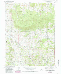
1983 Map of Thirtynine Mile Mountain
USGS Topo · Published 1985About this map
Thirtynine Mile Mountain dominates this mid-1980s topography, standing as a central high point within the Pike National Forest. The landscape is defined by a dense network of high-elevation drainages, including Currant Creek and Fourmile Creek, which carve through the volcanic terrain of southern Park County. The small settlement of Guffey is situated in the southeastern corner, serving as a hub for the surrounding ranching and mining land.
Find a feature on this map
24 named features on this map. Tap any name to fly to it.
Don’t see what you’re looking for? This feature index may not catch every label — zoom into the map to look around manually.
Map Details
Editions of this 1983 Thirtynine Mile Mountain Map
2 editions found
Other maps of this area

1894 · Pikes Peak
USGS Topo · 1:125,000

1901 · Pikes Peak
USGS Topo · 1:125,000

1942 · Cover Mtn.
USGS Topo · 1:62,500

1948 · Cover Mtn.
USGS Topo · 1:62,500

1954 · Pueblo
USGS Topo · 1:250,000

1956 · Elevenmile Canyon
USGS Topo · 1:24,000

1956 · Guffey NW
USGS Topo · 1:24,000

1956 · Spinney Mountain
USGS Topo · 1:24,000

1957 · Pueblo
USGS Topo · 1:250,000

1958 · Pueblo
USGS Topo · 1:250,000