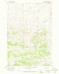
1967 Map of Thompson Creek
USGS Topo · Published 1971About this map
The Northern Cheyenne Indian Reservation occupies the eastern boundary of this Big Horn County landscape, where the high plains meet a complex network of drainage basins. Mapped in the late 1960s, the terrain is defined by the winding course of Thompson Creek and its tributary, Little Thompson Creek, which carve deep valleys through the rangeland. Human activity is sparse and centered on livestock ranching, exemplified by the Spear Ranch and an adjacent Landing Strip located near the confluence of Dry Creek and Corral Creek. To the north, the headwaters of Middle Fork Davis Creek and a small reach of Rosebud Cr indicate the watershed's connectivity. Numerous Spring and Well labels scattered across the quadrangle highlight the critical importance of water management for cattle operations in this arid Montana environment, connected only by winding Jeep Trails.
Find a feature on this map
15 named features on this map. Tap any name to fly to it.
Don’t see what you’re looking for? This feature index may not catch every label — zoom into the map to look around manually.
Map Details
Editions of this 1967 Thompson Creek Map
2 editions found
Other maps of this area

1894 · Rosebud
USGS Topo · 1:125,000

1901 · Rosebud
USGS Topo · 1:125,000

1954 · Hardin
USGS Topo · 1:250,000

1957 · Hardin
USGS Topo · 1:250,000

1958 · Hardin
USGS Topo · 1:250,000

1958 · Busby
USGS Topo · 1:24,000

1958 · Birdseye Spring
USGS Topo · 1:24,000

1967 · Wolf Mountain Lookout
USGS Topo · 1:24,000

1967 · Kirby
USGS Topo · 1:24,000
1967 · Jeans Fork SE
USGS Topo · 1:24,000