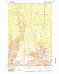
1969 Map of Thompson Flat
USGS Topo · Published 1984About this map
Umatilla National Forest defines the character of this 1969 survey, showing a landscape of high plateaus and deep drainage systems within the Blue Mountains. The terrain is anchored by expansive features like Thompson Flat and Buckaroo Flat, separated by the steep relief of Potamus Point. These highlands are etched by a dense network of seasonal and perennial waters, including Potamus Creek, Matlock Creek, and Thompson Creek, which culminates at Thompson Falls.
Find a feature on this map
39 named features on this map. Tap any name to fly to it.
Don’t see what you’re looking for? This feature index may not catch every label — zoom into the map to look around manually.
Map Details
Editions of this 1969 Thompson Flat Map
2 editions found

Other maps of this area

1950 · Ritter
USGS Topo · 1:62,500

1951 · Monument
USGS Topo · 1:62,500

1952 · Ritter
USGS Topo · 1:62,500

1953 · Pendleton
USGS Topo · 1:250,000

1955 · Canyon City
USGS Topo · 1:250,000

1956 · Pendleton
USGS Topo · 1:250,000

1959 · Canyon City
USGS Topo · 1:250,000

1969 · Lake Penland
USGS Topo · 1:24,000

1969 · Sugarbowl Creek
USGS Topo · 1:24,000

1969 · Deerhorn Creek
USGS Topo · 1:24,000