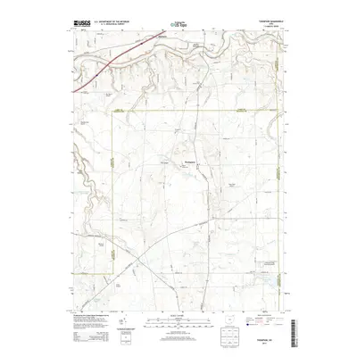
2013 Map of Thompson
USGS Topo · Published 2013About this map
The Grand River carves a deep valley through the northern reach of this landscape, creating the dramatic Madison Palisades before flowing west toward the lake. This high-plateau region of Geauga and Lake Counties is defined by its numerous watercourses, including Griswold Cr, Talcott Cr, and Phelps Cr, which drain the elevated terrain surrounding Thompson. The local geography is marked by a distinctive network of private airfields and regional landmarks like The Ledges, reflecting a rural character that persists despite proximity to larger suburban centers.
Find a feature on this map
71 named features on this map. Tap any name to fly to it.
Don’t see what you’re looking for? This feature index may not catch every label — zoom into the map to look around manually.
Map Details
Editions of this 2013 Thompson Map
This is the sole edition of this map. No revisions or reprints were ever made.
Other maps of this area

1904 · Chardon
USGS Topo · 1:62,500

1905 · Ashtabula
USGS Topo · 1:62,500

1905 · Perry
USGS Topo · 1:62,500

1905 · Jefferson
USGS Topo · 1:62,500

1906 · Chardon
USGS Topo · 1:62,500

1907 · Jefferson
USGS Topo · 1:62,500

1950 · Cleveland
USGS Topo · 1:250,000

1953 · Chardon
USGS Topo · 1:24,000

1956 · Cleveland
USGS Topo · 1:250,000
1959 · East Claridon
USGS Topo · 1:24,000