
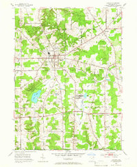
1953 Map of Chardon
USGS Topo · Published 1954About this map
Chardon serves as the focal point of this mid-century Geauga County landscape, situated within the historic Connecticut Western Reserve. The 1950s terrain is marked by the headwaters of the Cuyahoga River and its East Branch, which flow through a network of small lakes including Bass Lake and Lake Aquilla. These water bodies and the surrounding wetlands suggest a glaciated landscape that transitioned from early agricultural land lines into the suburban and industrial patterns seen here.
Find a feature on this map
52 named features on this map. Tap any name to fly to it.
Don’t see what you’re looking for? This feature index may not catch every label — zoom into the map to look around manually.
Map Details
Editions of this 1953 Chardon Map
2 editions found
Other maps of this area

1904 · Chardon
USGS Topo · 1:62,500

1905 · Garrettsville
USGS Topo · 1:62,500

1905 · Mentor
USGS Topo · 1:62,500

1906 · Chardon
USGS Topo · 1:62,500

1906 · Chagrin Falls
USGS Topo · 1:62,500

1907 · Garrettsville
USGS Topo · 1:62,500

1907 · Mentor
USGS Topo · 1:62,500

1908 · Chagrin Falls
USGS Topo · 1:62,500

1950 · Cleveland
USGS Topo · 1:250,000

1953 · South Russell
USGS Topo · 1:24,000