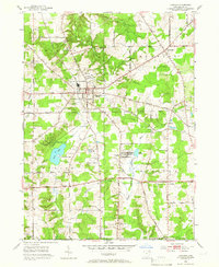
1953 Map of Chardon
USGS Topo · Published 1966About this map
Chardon serves as the focal point of this Geauga County landscape during the early 1950s, revealing a mid-century network of township roads and emerging suburban development. As part of the Connecticut Western Reserve, the map shows land lines established by the Connecticut Land Company, underpinning a layout that includes the village of Aquilla and the township centers of Hambden and Claridon. The presence of the County Home and several local burial grounds, including Maple Hill Cem and Claridon Cem, provides essential points of reference for genealogists studying the area's resident families.
Find a feature on this map
56 named features on this map. Tap any name to fly to it.
Don’t see what you’re looking for? This feature index may not catch every label — zoom into the map to look around manually.
Map Details
Editions of this 1953 Chardon Map
2 editions found
Other maps of this area

1904 · Chardon
USGS Topo · 1:62,500

1905 · Garrettsville
USGS Topo · 1:62,500

1905 · Mentor
USGS Topo · 1:62,500

1906 · Chardon
USGS Topo · 1:62,500

1906 · Chagrin Falls
USGS Topo · 1:62,500

1907 · Garrettsville
USGS Topo · 1:62,500

1907 · Mentor
USGS Topo · 1:62,500

1908 · Chagrin Falls
USGS Topo · 1:62,500

1950 · Cleveland
USGS Topo · 1:250,000

1953 · Chardon
USGS Topo · 1:24,000