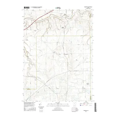
2016 Map of Thompson
USGS Topo · Published 2016About this map
Thompson sits atop a distinctive plateau punctuated by The Ledges, overlooking a landscape defined by the intersection of Geauga, Lake, and Ashtabula counties. This 2016 survey illustrates the rural character of the region, where family and community heritage is preserved at Evergreen Cem and Maple Grove Cem. The northern reach of the map is dominated by the Grand River corridor and the Madison Palisades, while the southern portion transitions into the headwaters of several drainages, including Trumbull Cr and Spring Cr. Aviation history is visible through a high concentration of small airstrips like Birdland Airport and Curtis Airport, alongside the specialized Thompson Drag Raceway Airport. This map serves as a detailed record of the township's modern infrastructure, from the winding Rock Creek Rd to the secluded waters of Lake Erie Girl Scout Lake.
Find a feature on this map
54 named features on this map. Tap any name to fly to it.
Don’t see what you’re looking for? This feature index may not catch every label — zoom into the map to look around manually.
Map Details
Editions of this 2016 Thompson Map
This is the sole edition of this map. No revisions or reprints were ever made.
Other maps of this area

1904 · Chardon
USGS Topo · 1:62,500

1905 · Ashtabula
USGS Topo · 1:62,500

1905 · Perry
USGS Topo · 1:62,500

1905 · Jefferson
USGS Topo · 1:62,500

1906 · Chardon
USGS Topo · 1:62,500

1907 · Jefferson
USGS Topo · 1:62,500

1950 · Cleveland
USGS Topo · 1:250,000

1953 · Chardon
USGS Topo · 1:24,000

1956 · Cleveland
USGS Topo · 1:250,000
1959 · East Claridon
USGS Topo · 1:24,000