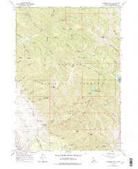
1966 Map of Thompson Peak
USGS Topo · Published 1977About this map
Irwin and the fertile Swan Valley occupy the southwestern corner of this survey, where the valley floor meets the steep rise of the Targhee National Forest. The landscape is defined by the drainage of Palisades Lake, with both the Lower Palisades Lake and Upper Palisades Lake tucked into deep canyons carved by mountain streams. A network of primitive transport routes, including numerous Pack Trails and a Jeep Trail, provides the only access into the high-altitude terrain of Paradise Basin and peaks such as Thompson Peak and Atkinson Peak. Evidence of local industry and resource use appears in place names like Limekiln Canyon and Sawmill Canyon, while recreation is established at the Palisades Creek Campground. The map illustrates the sharp transition from the flat agricultural lands of Palisades Bench to the jagged ridgelines of Rocky Ridge and Baldy Mtn.
Find a feature on this map
44 named features on this map. Tap any name to fly to it.
Don’t see what you’re looking for? This feature index may not catch every label — zoom into the map to look around manually.
Map Details
Editions of this 1966 Thompson Peak Map
3 editions found
Other maps of this area

1932 · Irwin
USGS Topo · 1:96,000

1935 · Irwin
USGS Topo · 1:125,000

1943 · Driggs
USGS Topo · 1:62,500

1943 · Garns Mtn
USGS Topo · 1:62,500

1946 · Driggs
USGS Topo · 1:62,500

1946 · Garns Mtn
USGS Topo · 1:62,500

1955 · Driggs
USGS Topo · 1:250,000

1958 · Driggs
USGS Topo · 1:250,000

1962 · Driggs
USGS Topo · 1:250,000
1966 · Palisades Peak
USGS Topo · 1:24,000