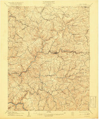
1907 Map of Thornton
USGS Topo · Published 1918About this map
Newburg and Tunnelton serve as industrial anchors along the Baltimore and Ohio RR in this early 20th-century landscape. The map captures the complex terrain of the Appalachian Plateau where the Northwestern Virginia RR and the historic Beverly Turnpike navigate the winding valleys of Threefork Creek and Raccoon Creek. This survey provides a precise record of the upland rural community before modern highway expansion, featuring numerous small-scale settlements like Evansville, Fellowsville, and Gladesville.
Find a feature on this map
82 named features on this map. Tap any name to fly to it.
Don’t see what you’re looking for? This feature index may not catch every label — zoom into the map to look around manually.
Map Details
Editions of this 1907 Thornton Map
2 editions found
Other maps of this area

1886 · St. George
USGS Topo · 1:125,000

1891 · St. George
USGS Topo · 1:125,000

1902 · Fairmont
USGS Topo · 1:62,500

1902 · Morgantown
USGS Topo · 1:62,500

1904 · Bruceton
USGS Topo · 1:62,500

1904 · Philippi
USGS Topo · 1:62,500

1904 · Blacksville
USGS Topo · 1:62,500

1907 · Thornton
USGS Topo · 1:62,500

1907 · Kingwood
USGS Topo · 1:62,500

1907 · Belington
USGS Topo · 1:62,500