
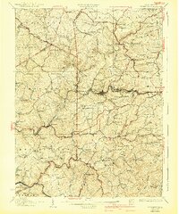
1926 Map of Thornton
USGS Topo · Published 1926About this map
Baltimore and Ohio rail lines dominate the transport geography of this section of West Virginia, connecting coal and timber towns like Newburg and Tunnelton. The landscape is defined by its deep creek valleys, where Threefork Creek and Sandy Creek have carved routes for secondary travel and early settlement. Along the Beverly Road, small crossroads like Evansville and Fellowsville served as vital junctions during a period of steady industrial and agricultural activity.
Find a feature on this map
138 named features on this map. Tap any name to fly to it.
Don’t see what you’re looking for? This feature index may not catch every label — zoom into the map to look around manually.
Map Details
Editions of this 1926 Thornton Map
2 editions found
Other maps of this area

1886 · St. George
USGS Topo · 1:125,000

1891 · St. George
USGS Topo · 1:125,000

1902 · Fairmont
USGS Topo · 1:62,500

1902 · Morgantown
USGS Topo · 1:62,500

1904 · Bruceton
USGS Topo · 1:62,500

1904 · Philippi
USGS Topo · 1:62,500

1904 · Blacksville
USGS Topo · 1:62,500

1907 · Thornton
USGS Topo · 1:62,500

1907 · Kingwood
USGS Topo · 1:62,500

1907 · Belington
USGS Topo · 1:62,500