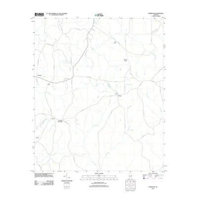
2011 Map of Thornton
USGS Topo · Published 2011About this map
Thornton and the surrounding Tallapoosa County countryside are defined by a network of rural roads and creek drainages in this 2011 survey. The map records several small communities, including Roxana and Simmons Crossroads, which serve as local landmarks within the agricultural landscape. Genealogists will find significant value in the distribution of family and community burial grounds, such as the Meadows-Robinson Cemetery and Shiloh Cemetery, scattered across the undulating terrain. A dense network of waterways, including Wind Creek, Cane Creek, and Ropes Creek, dictates the placement of the road system, which transitions from named county routes like Thornton Cutoff Rd to numbered paths like Lee Road 71. This layout reflects the long-standing rural structure of eastern Alabama, where small settlements remain centered around key intersections and historic church sites.
Find a feature on this map
43 named features on this map. Tap any name to fly to it.
Don’t see what you’re looking for? This feature index may not catch every label — zoom into the map to look around manually.
Map Details
Editions of this 2011 Thornton Map
This is the sole edition of this map. No revisions or reprints were ever made.
Other maps of this area

1906 · Dadeville
USGS Topo · 1:125,000

1955 · Phenix City
USGS Topo · 1:250,000

1957 · Phenix City
USGS Topo · 1:250,000

1958 · Phenix City
USGS Topo · 1:250,000

1971 · Waverly
USGS Topo · 1:24,000
1971 · Dadeville
USGS Topo · 1:24,000

1971 · Ponders
USGS Topo · 1:24,000

1971 · Carrville
USGS Topo · 1:24,000

1971 · Loachapoka
USGS Topo · 1:24,000
1971 · Camp Hill
USGS Topo · 1:24,000