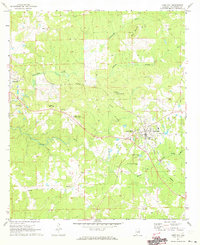
1971 Map of Camp Hill
USGS Topo · Published 1973About this map
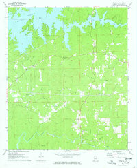
The town of Camp Hill serves as the focal point of this 1971 survey, showing a well-established community defined by its educational and transport infrastructure. The Central of Georgia Railroad bisects the landscape, connecting the main settlement with outlying areas like Slaughters and Agricola. Local genealogy is well-documented through numerous burial grounds, including the Tallapoosa County Memorial Gardens, Langley Cem, and Spring Hill Cem. Significant institutional presence is noted at the Lyman Ward Military Academy and Tallapoosa Academy, reflecting the area's historical emphasis on education. The terrain is characterized by the winding paths of Sandy Creek and Chattasofka Creek, which navigate around elevations like Doss Mountain. This map documents a transitional period when small-scale aviation was emerging at the Camp Hill-East Tallapoosa Airport, while rural life still centered around local landmarks like Beulah No 2 Ch and Mt Carmel Ch.
Find a feature on this map
30 named features on this map. Tap any name to fly to it.
Don’t see what you’re looking for? This feature index may not catch every label — zoom into the map to look around manually.
Map Details
Editions of this 1971 Camp Hill Map
2 editions found
Other maps of this area

1906 · Dadeville
USGS Topo · 1:125,000

1955 · Phenix City
USGS Topo · 1:250,000

1957 · Phenix City
USGS Topo · 1:250,000

1958 · Phenix City
USGS Topo · 1:250,000
1971 · Waverly
USGS Topo · 1:24,000
1971 · Dadeville
USGS Topo · 1:24,000
1971 · Ponders
USGS Topo · 1:24,000
1971 · Buttston
USGS Topo · 1:24,000
1971 · Thornton
USGS Topo · 1:24,000

1971 · Dudleyville
USGS Topo · 1:24,000