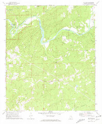
1971 Map of Buttston
USGS Topo · Published 1973About this map
Horseshoe Bend National Military Park dominates the northwest corner of this landscape, marking the significant bend in the Tallapoosa River where the Battleground Monument stands. The river winds eastward through the terrain, passing Millers Bridge and the churning waters of Griffin Shoals, while the surrounding hills are dotted with small rural communities and family-named creek basins. Long-standing local gathering points like Poplar Springs Ch and Lebanon Ch define the social geography of the era, situated among numerous gravel pits that hint at the local resource extraction during the early 1970s.
Find a feature on this map
33 named features on this map. Tap any name to fly to it.
Don’t see what you’re looking for? This feature index may not catch every label — zoom into the map to look around manually.
Map Details
Editions of this 1971 Buttston Map
2 editions found
Other maps of this area

1891 · Ashland
USGS Topo · 1:125,000

1906 · Dadeville
USGS Topo · 1:125,000

1953 · Atlanta
USGS Topo · 1:250,000

1955 · Phenix City
USGS Topo · 1:250,000

1957 · Phenix City
USGS Topo · 1:250,000

1957 · Atlanta
USGS Topo · 1:250,000

1958 · Phenix City
USGS Topo · 1:250,000

1958 · Atlanta
USGS Topo · 1:250,000

1969 · New Site
USGS Topo · 1:24,000
1969 · Daviston
USGS Topo · 1:24,000