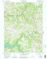
1958 Map of Thornton
USGS Topo · Published 1989About this map
The Baltimore and Ohio Railroad corridor through the northern sections of this survey serves as the primary artery for transportation and industry, connecting communities like Thornton and Blueville. Along this rail line and the parallel George Washington Highway, the landscape reveals an active industrial history evidenced by Kilns, a Clay Pit, and several Strip Mine operations. The rural character of Taylor County is further defined by a dense network of country churches, including Bethany Ch, Wesley Chapel, and the Knottsville-Wesleyan Ch. To the south, the Tygart Valley River flows into the Tygart Lake State Park Reservoir, creating a significant water feature that dominates the southern boundary. This map captures the region during a period of transition, where small settlements such as Knottsville and Hiram remained centered around local faith and small-scale extractive industries.
Find a feature on this map
68 named features on this map. Tap any name to fly to it.
Don’t see what you’re looking for? This feature index may not catch every label — zoom into the map to look around manually.
Map Details
Editions of this 1958 Thornton Map
4 editions found
Other maps of this area

1886 · St. George
USGS Topo · 1:125,000

1891 · St. George
USGS Topo · 1:125,000

1902 · Fairmont
USGS Topo · 1:62,500

1904 · Philippi
USGS Topo · 1:62,500

1907 · Thornton
USGS Topo · 1:62,500

1907 · Belington
USGS Topo · 1:62,500

1923 · Fairmont
USGS Topo · 1:62,500

1925 · Philippi
USGS Topo · 1:62,500

1926 · Fairmont
USGS Topo · 1:62,500

1926 · Thornton
USGS Topo · 1:62,500