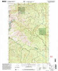
2001 Map of Thrapp Mtn
USGS Topo · Published 2004About this map
Thrapp Mountain and the high ridges of the Okanogan National Forest dominate this terrain near the turn of the 21st century. The map provides a detailed view of the complex drainages and resource extraction sites that have shaped the local economy. At the western edge, the Red Shirt Mine and several unnamed prospects indicate a history of mineral exploration along the slopes leading into Finley Canyon.
Find a feature on this map
20 named features on this map. Tap any name to fly to it.
Don’t see what you’re looking for? This feature index may not catch every label — zoom into the map to look around manually.
Map Details
Editions of this 2001 Thrapp Mtn Map
This is the sole edition of this map. No revisions or reprints were ever made.
Other maps of this area

1899 · Methow
USGS Topo · 1:125,000

1901 · Methow
USGS Topo · 1:125,000

1905 · Okanogan
USGS Topo · 1:125,000

1954 · Okanogan
USGS Topo · 1:250,000

1955 · Concrete
USGS Topo · 1:250,000

1956 · Loup Loup
USGS Topo · 1:62,500

1957 · Brewster
USGS Topo · 1:62,500

1958 · Concrete
USGS Topo · 1:250,000

1958 · Okanogan
USGS Topo · 1:250,000

1962 · Concrete
USGS Topo · 1:250,000