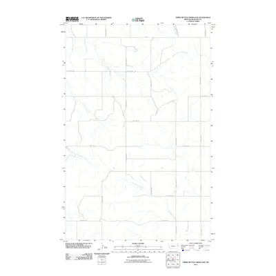
2011 Map of Three Buttes Creek East
USGS Topo · Published 2011About this map
Three Buttes Creek and its drainage network define the topography of this portion of Richland County, flowing through a landscape structured by a precise grid of rural routes. The area is dominated by the sprawling tributaries of North Fork Lone Tree Creek and Timber Creek, which cut across the high plains of eastern Montana. This 2011 survey illustrates the modern layout of secondary infrastructure, including the Fas 201 corridor and a series of north-south local roads such as County Rd-331 and County Rd-333. The map preserves the exact alignment of these routes, including Cheney Creek, providing a detailed record of the drainage patterns and land-use divisions that characterize the region's agricultural and ranching environment.
Find a feature on this map
16 named features on this map. Tap any name to fly to it.
Don’t see what you’re looking for? This feature index may not catch every label — zoom into the map to look around manually.
Map Details
Editions of this 2011 Three Buttes Creek East Map
This is the sole edition of this map. No revisions or reprints were ever made.
Other maps of this area

1909 · Glendive
USGS Topo · 1:250,000

1954 · Glendive
USGS Topo · 1:250,000

1957 · Glendive
USGS Topo · 1:250,000

1958 · Glendive
USGS Topo · 1:250,000

1966 · Crane NW
USGS Topo · 1:24,000

1972 · Girard
USGS Topo · 1:24,000
1972 · Blue Hill
USGS Topo · 1:24,000

1972 · Fox Lake
USGS Topo · 1:24,000

1972 · Lambert
USGS Topo · 1:24,000

1981 · Sidney
USGS Topo · 1:100,000