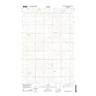
2014 Map of Three Buttes Creek East
USGS Topo · Published 2014About this map
Three Buttes Creek and its seasonal tributaries define this section of the northern plains, where a network of section-line roads reveals the enduring geometry of the Public Land Survey System. The map shows the intersection of several townships, including t24n r56e and t25n r55e, underscoring the rural structure of the region in the early 21st century. High-elevation points are drained by numerous small waterways such as E Charlie Cr and Cheney Cr, which flow toward larger drainages beyond the quadrangle boundary. The presence of MT-201 in the northern portion of the sheet provides the primary East-West transit corridor through this sparsely populated landscape. While many modern topographic sheets focus on urban development, this survey highlights the persistence of large-scale agricultural and ranching divisions, marked by dozens of numbered county roads including Co Road 132 and Co Road 128.
Find a feature on this map
25 named features on this map. Tap any name to fly to it.
Don’t see what you’re looking for? This feature index may not catch every label — zoom into the map to look around manually.
Map Details
Editions of this 2014 Three Buttes Creek East Map
This is the sole edition of this map. No revisions or reprints were ever made.
Other maps of this area

1909 · Glendive
USGS Topo · 1:250,000

1954 · Glendive
USGS Topo · 1:250,000

1957 · Glendive
USGS Topo · 1:250,000

1958 · Glendive
USGS Topo · 1:250,000

1966 · Crane NW
USGS Topo · 1:24,000

1972 · Girard
USGS Topo · 1:24,000
1972 · Blue Hill
USGS Topo · 1:24,000

1972 · Fox Lake
USGS Topo · 1:24,000

1972 · Lambert
USGS Topo · 1:24,000

1981 · Sidney
USGS Topo · 1:100,000