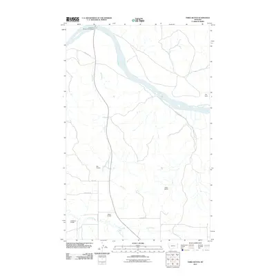
2011 Map of Three Buttes
USGS Topo · Published 2011About this map
The Missouri River winds through the northern portion of this Roosevelt County landscape, defined by a series of deep drainage coulees and the prominent rise of the Three Buttes. The river's passage is marked by the Culbertson Missouri River Bridge, a vital infrastructure point in this otherwise open terrain of the northern Great Plains. The topography is dominated by erosion-carved features such as Elm Coulee, Shaw Coulee, and Goodman Coulee, which channel seasonal runoff toward larger tributaries like Cherry Creek and Day Creek. The mapping of these ephemeral watercourses, including the S Fk Cherry Cr and East Hardscrabble Creek, illustrates the complex hydrological network required to drain the high benchlands south of the river valley.
Find a feature on this map
17 named features on this map. Tap any name to fly to it.
Don’t see what you’re looking for? This feature index may not catch every label — zoom into the map to look around manually.
Map Details
Editions of this 2011 Three Buttes Map
This is the sole edition of this map. No revisions or reprints were ever made.
Other maps of this area

1909 · Glendive
USGS Topo · 1:250,000

1954 · Glendive
USGS Topo · 1:250,000

1954 · Wolf Point
USGS Topo · 1:250,000

1957 · Glendive
USGS Topo · 1:250,000

1958 · Wolf Point
USGS Topo · 1:250,000

1958 · Glendive
USGS Topo · 1:250,000

1969 · Cedar Coulee
USGS Topo · 1:24,000
1969 · Culbertson
USGS Topo · 1:24,000

1969 · Three Buttes
USGS Topo · 1:24,000

1969 · Dugout Creek
USGS Topo · 1:24,000