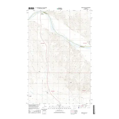
2017 Map of Three Buttes
USGS Topo · Published 2017About this map
The Missouri River cuts a wide, meandering path across this landscape, serving as the natural boundary between Roosevelt and Richland counties. The Culbertson Missouri River Bridge provides a vital link across the water, anchoring the northern portion of the quadrangle. South of the river, the terrain is defined by a series of significant drainage features and coulees that cut through the high plains, including Elm Coulee, Shaw Coulee, and Goodman Coulee. This area illustrates the typical agricultural and ranching layout of eastern Montana, where a sparse network of section-line roads like Co Rd 146 and Co Rd 338 connect isolated homesteads and grazing lands. Rising prominently in the south-central portion of the map are the Three Buttes, which serve as a distinctive topographic landmark overlooking the nearby Cherry Cr and E Hardscrabble Cr drainages.
Find a feature on this map
24 named features on this map. Tap any name to fly to it.
Don’t see what you’re looking for? This feature index may not catch every label — zoom into the map to look around manually.
Map Details
Editions of this 2017 Three Buttes Map
This is the sole edition of this map. No revisions or reprints were ever made.
Other maps of this area

1909 · Glendive
USGS Topo · 1:250,000

1954 · Glendive
USGS Topo · 1:250,000

1954 · Wolf Point
USGS Topo · 1:250,000

1957 · Glendive
USGS Topo · 1:250,000

1958 · Wolf Point
USGS Topo · 1:250,000

1958 · Glendive
USGS Topo · 1:250,000

1969 · Cedar Coulee
USGS Topo · 1:24,000
1969 · Culbertson
USGS Topo · 1:24,000

1969 · Three Buttes
USGS Topo · 1:24,000

1969 · Dugout Creek
USGS Topo · 1:24,000