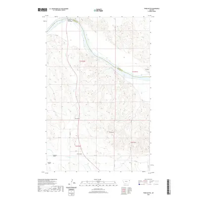
2020 Map of Three Buttes
USGS Topo · Published 2020About this map
Three Buttes rises as the central topographic feature of this Missouri River landscape, where the border of Roosevelt and Richland counties follows the winding river channel. The northern reach of the map is defined by the Missouri River, crossed only by the Culbertson-Missouri River Bridge as the waterway bends eastward. This 2020 survey illustrates a sparsely settled but deeply carved terrain of drainage systems and coulees, including Elm Coulee, Shaw Coulee, and Goodman Coulee, which cut through the high plains toward the river basin. The map tracks a network of county roads, such as Co RD 146 and Co RD 338, that navigate the intricate system of ridges and seasonal watercourses like Cherry Cr and Day Cr. These features demonstrate the enduring rural character of northeastern Montana, where land use is dictated by the rugged breaks leading down to the Missouri River.
Find a feature on this map
25 named features on this map. Tap any name to fly to it.
Don’t see what you’re looking for? This feature index may not catch every label — zoom into the map to look around manually.
Map Details
Editions of this 2020 Three Buttes Map
This is the sole edition of this map. No revisions or reprints were ever made.
Other maps of this area

1909 · Glendive
USGS Topo · 1:250,000

1954 · Glendive
USGS Topo · 1:250,000

1954 · Wolf Point
USGS Topo · 1:250,000

1957 · Glendive
USGS Topo · 1:250,000

1958 · Wolf Point
USGS Topo · 1:250,000

1958 · Glendive
USGS Topo · 1:250,000

1969 · Cedar Coulee
USGS Topo · 1:24,000
1969 · Culbertson
USGS Topo · 1:24,000

1969 · Three Buttes
USGS Topo · 1:24,000

1969 · Dugout Creek
USGS Topo · 1:24,000