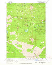
1959 Map of Three Fingered Jack
USGS Topo · Published 1964About this map
Three Fingered Jack and Mt Washington anchor this late 1950s survey of the High Cascades, where the Willamette National Forest meets the Deschutes National Forest. The landscape is dominated by volcanic features, from the massive lava fields around Belknap Crater and Little Belknap to the distinct profiles of Hoodoo Butte and Hayrick Butte. Settlement is sparse, centered on the strategic highway convergence at Santiam Junction.
Find a feature on this map
91 named features on this map. Tap any name to fly to it.
Don’t see what you’re looking for? This feature index may not catch every label — zoom into the map to look around manually.
Map Details
Editions of this 1959 Three Fingered Jack Map
4 editions found

Other maps of this area

1927 · Mt. Jefferson
USGS Topo · 1:125,000

1929 · Mill City
USGS Topo · 1:125,000

1929 · Three Sisters
USGS Topo · 1:125,000

1930 · Mt. Jefferson
USGS Topo · 1:125,000

1932 · Three Sisters
USGS Topo · 1:125,000

1934 · Mc Kenzie Bridge
USGS Topo · 1:96,000

1940 · Mc Kenzie Bridge
USGS Topo · 1:125,000

1953 · Salem
USGS Topo · 1:250,000

1954 · Salem
USGS Topo · 1:250,000

1955 · Echo Mountain
USGS Topo · 1:62,500