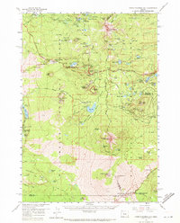
1959 Map of Three Fingered Jack
USGS Topo · Published 1971About this map
Santiam Highway and the McKenzie Highway converge in this high-altitude landscape where the Cascade Range defines the boundary between the Willamette National Forest and Deschutes National Forest. The 1959 survey records a transition from the historic Old Santiam Wagon Road and an Old Railroad Grade to modern automotive access at Santiam Junction. Distinctive geological features dominate the terrain, from the sharp peaks of Three Fingered Jack and Mt Washington to the cinder-strewn basins around Belknap Crater and Nash Crater. A network of high lakes like Big Lake, Duffy Lake, and Square Lake serve as focal points for early recreational developments such as Camp Tamarack and numerous forest camps, while legacy industrial markers like the Cinder Pits near Potato Hill reflect the local extraction of volcanic materials.
Find a feature on this map
97 named features on this map. Tap any name to fly to it.
Don’t see what you’re looking for? This feature index may not catch every label — zoom into the map to look around manually.
Map Details
Editions of this 1959 Three Fingered Jack Map
4 editions found

Other maps of this area

1927 · Mt. Jefferson
USGS Topo · 1:125,000

1929 · Mill City
USGS Topo · 1:125,000

1929 · Three Sisters
USGS Topo · 1:125,000

1930 · Mt. Jefferson
USGS Topo · 1:125,000

1932 · Three Sisters
USGS Topo · 1:125,000

1934 · Mc Kenzie Bridge
USGS Topo · 1:96,000

1940 · Mc Kenzie Bridge
USGS Topo · 1:125,000

1953 · Salem
USGS Topo · 1:250,000

1954 · Salem
USGS Topo · 1:250,000

1955 · Echo Mountain
USGS Topo · 1:62,500