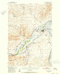
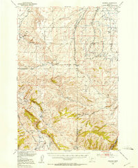
1950 Map of Three Forks
USGS Topo · Published 1953About this map
Three Forks sits at the vital hydrological confluence where the Jefferson River, Madison River, and Gallatin River meet to form the Missouri River. This post-war survey illustrates a landscape defined by water management and heavy rail infrastructure, featuring the Chicago Milwaukee St Paul and Pacific and Northern Pacific railroads. The map reveals the intricate network of irrigation necessary for Gallatin Valley ranching, documented through labels like the Lower Jefferson Ditch and Buttleman Ditch. Rural life is anchored by family-named landmarks and local institutions, including the Silver Sage Ranch, Jefferson Sch, and the Mt Green Cem near the town of Willow Creek. Industrial activity is noted at the Copper City open pit mine and various gravel operations, providing a window into the regional economy before modern interstate development.
Find a feature on this map
43 named features on this map. Tap any name to fly to it.
Don’t see what you’re looking for? This feature index may not catch every label — zoom into the map to look around manually.
Map Details
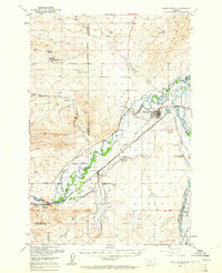
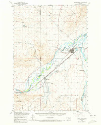
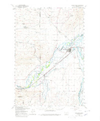
Editions of this 1950 Three Forks Map
4 editions found
Other maps of this area

1886 · Fort Logan
USGS Topo · 1:250,000

1888 · Three Forks
USGS Topo · 1:250,000

1894 · Three Forks
USGS Topo · 1:250,000

1895 · Three Forks
USGS Topo · 1:250,000

1947 · Bozeman
USGS Topo · 1:250,000

1948 · Bozeman
USGS Topo · 1:250,000

1948 · White Sulphur Springs
USGS Topo · 1:250,000

1949 · Radersburg
USGS Topo · 1:62,500
1949 · Anceney
USGS Topo · 1:62,500
1949 · Manhattan
USGS Topo · 1:62,500
Featured Places
- Three Forks, MT
- Three Forks Junction, MT
- Willow Creek, MT
- Copper City, MT
- Murphys Trailer Court, Three Forks