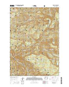
2014 Map of Three Lynx
USGS Topo · Published 2014About this map
Three Lynx stands as a small community enclave within the extensive wilderness of the Mount Hood National Forest. The landscape is defined by the steep drainage basins of the Clackamas River and the Roaring River, where deep canyons and high ridges like Indian Ridge and the Fish Creek Divide dictate the layout of forest roads and trails. The map reveals a high-elevation network of alpine water bodies, including Huxley Lake, Shining Lake, and Serene Lake, many of which are tucked into glacial cirques below peaks like Tumala Mtn. Evidence of infrastructure is seen in the southern portion of the map, where the Pipeline Rd and Clackamas Hwy follow the river corridor through a geological bottleneck known as The Narrows. This layout reflects a decades-long history of forest management and hydroelectric power development centered around the remote Clackamas River canyon.
Find a feature on this map
41 named features on this map. Tap any name to fly to it.
Don’t see what you’re looking for? This feature index may not catch every label — zoom into the map to look around manually.
Map Details
Editions of this 2014 Three Lynx Map
This is the sole edition of this map. No revisions or reprints were ever made.
Other maps of this area

1916 · Estacada
USGS Topo · 1:125,000

1924 · Mount Hood
USGS Topo · 1:125,000

1927 · Mount Hood
USGS Topo · 1:125,000

1948 · Vancouver
USGS Topo · 1:250,000

1950 · Vancouver
USGS Topo · 1:250,000

1950 · Vancouver
USGS Topo · 1:250,000

1953 · The Dalles
USGS Topo · 1:250,000

1955 · Cherryville
USGS Topo · 1:62,500

1956 · The Dalles
USGS Topo · 1:250,000

1956 · Fish Creek Mtn
USGS Topo · 1:62,500