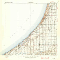
1930 Map of Three Oaks
USGS Topo · Published 1946About this map
Lake Michigan dominates the western edge of this Berrien County landscape, where massive coastal formations like Great Warren Dune and Pikes Pk rise above the shoreline. Inland, a dense network of country schools, including Hathaway Sch and Landon Sch, anchors a farming region organized into townships like Chikaming and Weesaw. The Pere Marquette railroad runs parallel to the coast, connecting settlements from Bridgman and Sawyer down to the rail hub at New Buffalo. This 1920s topography captures the area before modern development, revealing a landscape of small-scale agriculture drained by the Galien River and its branches. Local landmarks such as Forest Lawn Cemetery and the River Church provide essential reference points for those tracing the social geography of the early twentieth century.
Find a feature on this map
74 named features on this map. Tap any name to fly to it.
Don’t see what you’re looking for? This feature index may not catch every label — zoom into the map to look around manually.
Map Details
Editions of this 1930 Three Oaks Map
3 editions found
Other maps of this area

1927 · Niles
USGS Topo · 1:62,500

1927 · Benton Harbor
USGS Topo · 1:62,500

1930 · Three Oaks
USGS Topo · 1:62,500

1930 · Benton Harbor
USGS Topo · 1:62,500

1930 · Niles
USGS Topo · 1:62,500

1943 · Niles
USGS Topo · 1:62,500

1944 · Three Oaks
USGS Topo · 1:62,500

1953 · Chicago
USGS Topo · 1:250,000

1957 · Chicago
USGS Topo · 1:250,000

1958 · Lydick
USGS Topo · 1:24,000