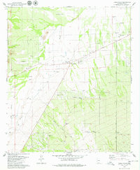
1979 Map of Three Points
USGS Topo · Published 1985About this map
Robles Junction, situated at the intersection of State Routes 86 and 286, serves as the primary hub of this arid Pima County landscape in the late 1970s. The community of Three Points centers around the Mary E Dill Sch and a local substation, while the surrounding desert terrain is defined by an extensive network of washes, including Brawley Wash and Mendoza Wash. To the south and west, the development of the Diamond Bell Ranch Road and several residential streets like Chumbler Road and Guy Street suggest the early stages of rural subdivision amidst traditional ranching operations. The map reveals the critical importance of water management in this environment, evidenced by numerous named sources such as Beers Well, Santa Teresa Well, and Javelina Tank. To the northwest, the foothills of the Roskruge Mountains provide a backdrop to more specialized sites, including a Rifle Range and several prospects.
Find a feature on this map
45 named features on this map. Tap any name to fly to it.
Don’t see what you’re looking for? This feature index may not catch every label — zoom into the map to look around manually.
Map Details
Editions of this 1979 Three Points Map
3 editions found
Other maps of this area

1920 · Arivaca
USGS Topo · 1:125,000

1925 · Samaniego Peak
USGS Topo · 1:62,500

1925 · San Xavier
USGS Topo · 1:62,500

1934 · Tucson Mountains
USGS Topo · 1:125,000

1939 · Twin Buttes
USGS Topo · 1:62,500

1940 · Palo Alto Ranch
USGS Topo · 1:62,500

1941 · Twin Buttes
USGS Topo · 1:62,500

1941 · Cocoraque Butte
USGS Topo · 1:62,500

1943 · Cocoraque Butte
USGS Topo · 1:62,500

1943 · Palo Alto Ranch
USGS Topo · 1:62,500