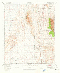
1947 Map of Three Rivers
USGS Topo · Published 1972About this map
The Southern Pacific railroad corridor serves as the primary artery through this high-desert landscape, connecting the small settlements of Oscura and Three Rivers along the eastern edge of the Tularosa Basin. Much of the western terrain is dedicated to specialized military operations, dominated by the White Sands Proving Ground and the Alamogordo Bombing Range, alongside the California Institute of Technology Ordnance Proving Ground Reservation. The mapping reveals a sparse but vital network of water sources essential for desert life, from Keen Spring to man-made structures like McDonald Tank. Ranching history is documented through several named properties including the Falls Ranch and Hatchet Ranch, as well as the Mayes Ranch, which already stood vacant by the time of the late-1940s field check. The Mescalero Indian Res border cuts across the southeastern corner, where the terrain begins its ascent into the mountains.
Find a feature on this map
35 named features on this map. Tap any name to fly to it.
Don’t see what you’re looking for? This feature index may not catch every label — zoom into the map to look around manually.
Map Details
Editions of this 1947 Three Rivers Map
2 editions found
Other maps of this area

1916 · Tularosa
USGS Topo · 1:125,000

1918 · Oscura Peak
USGS Topo · 1:125,000

1938 · Carrizozo
USGS Topo · 1:48,000

1943 · Carrizozo
USGS Topo · 1:62,500

1947 · Three Rivers
USGS Topo · 1:62,500

1947 · Capitol Peak
USGS Topo · 1:62,500

1948 · Chihuahua Ranch
USGS Topo · 1:62,500

1948 · Mockingbird Gap
USGS Topo · 1:62,500

1948 · Lumley Lake
USGS Topo · 1:62,500

1948 · Tularosa
USGS Topo · 1:62,500