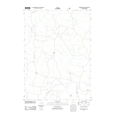
2012 Map of Threemile Butte
USGS Topo · Published 2012About this map
Threemile Butte stands as a central landmark in this high plains landscape of eastern Wyoming, where the drainage systems of the Cheyenne River define the local topography. This 2012 survey illustrates a sparse ranching and grazing environment marked by intermittent waterways like Sevenmile Cr, Crooked Cr, and Boggy Cr. The presence of the New Deal Number 1 Reservoir suggests the historical importance of water management in this arid region, likely supporting local livestock operations. Several family-named or descriptive terrain features such as Sheldon Hill, Charlies Draw, and Hungry Hollow provide specific points of reference for local historians. A network of rural routes, including Cheyenne River Rd and Dutch Joe Rd, connects these remote drainage basins and grazing lands.
Find a feature on this map
15 named features on this map. Tap any name to fly to it.
Don’t see what you’re looking for? This feature index may not catch every label — zoom into the map to look around manually.
Map Details
Editions of this 2012 Threemile Butte Map
This is the sole edition of this map. No revisions or reprints were ever made.
Other maps of this area

1899 · Newcastle
USGS Topo · 1:125,000

1901 · Newcastle
USGS Topo · 1:125,000

1955 · Newcastle
USGS Topo · 1:250,000

1958 · Newcastle
USGS Topo · 1:250,000

1979 · Newcastle
USGS Topo · 1:100,000

1981 · Horseshoe Bend
USGS Topo · 1:24,000

1981 · Threemile Butte
USGS Topo · 1:24,000
1981 · Little Alkali Creek
USGS Topo · 1:24,000
1981 · Bowen Flat
USGS Topo · 1:24,000
1981 · Boggy Reservoir
USGS Topo · 1:24,000