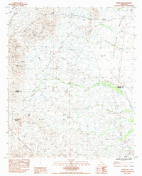
1983 Map of Thumb Peak
USGS Topo · Published 1991About this map
The Bradshaw Trail traverses this high desert terrain in the early 1980s, marking a historic route through the gap between the Mule Mountains and the northern reach of the Palo Verde Mountains. This area, characterized by the broad Palo Verde Mesa and numerous seasonal drainages like Sand Wash and Dry Wash, reveals a landscape of industrial extraction and natural landmarks. Local prospectors and historians can identify the Open Pit Mine near Opal Hill, as well as a Borrow Pit further north. Notable geographic markers include the distinctive Thumb Peak and the vital water source at Clapp Spring. The boundary between Riverside Co and Imperial Co bisects the quadrangle, which is also dominated by infrastructure such as the Doublewood Pole Powerline and a prominent Radio Tower.
Find a feature on this map
17 named features on this map. Tap any name to fly to it.
Don’t see what you’re looking for? This feature index may not catch every label — zoom into the map to look around manually.
Map Details
Editions of this 1983 Thumb Peak Map
2 editions found
Other maps of this area

1942 · Blythe
USGS Topo · 1:250,000

1945 · Cibola
USGS Topo · 1:62,500

1951 · Cibola
USGS Topo · 1:62,500

1952 · Mc Coy Spring
USGS Topo · 1:62,500

1952 · Palo Verde
USGS Topo · 1:24,000

1952 · Ripley
USGS Topo · 1:24,000

1953 · Palo Verde Mountains
USGS Topo · 1:62,500

1954 · Salton Sea
USGS Topo · 1:250,000

1955 · Salton Sea
USGS Topo · 1:250,000
1955 · Cibola
USGS Topo · 1:24,000