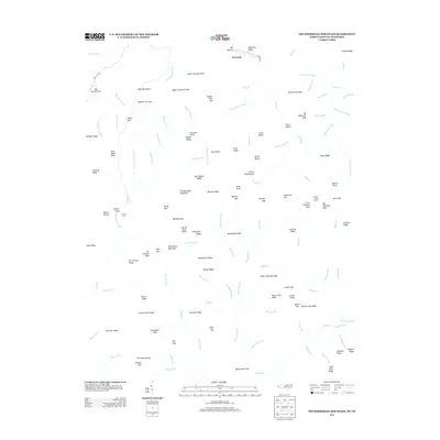
2013 Map of Thunderhead Mountain
USGS Topo · Published 2013About this map
Tremont sits at the northern edge of this high-elevation landscape where the Middle Prong Little River and its various prongs carve deep drainage patterns through the Great Smoky Mountains. The terrain is defined by prominent ridges and gaps that served as critical navigation points for early travelers, including Bote Mountain and Hickory Tree Gap. Hikers and researchers can identify the specific placement of the Derrick Knob Shelter along the high crests near Big Chestnut Bald. The naming conventions found throughout the sheet, such as Upper Chestnut Flats and Lower Chestnut Flats, suggest the historical vegetation patterns before the chestnut blight significantly altered the forest composition. The network of waterways, from the W Prong Little River to the small tributaries like Doghobble Br, illustrates a watershed largely shaped by the steep vertical relief and the presence of numerous named balds and gaps.
Find a feature on this map
133 named features on this map. Tap any name to fly to it.
Don’t see what you’re looking for? This feature index may not catch every label — zoom into the map to look around manually.
Map Details
Editions of this 2013 Thunderhead Mountain Map
This is the sole edition of this map. No revisions or reprints were ever made.
Other maps of this area

1886 · Knoxville
USGS Topo · 1:125,000

1892 · Knoxville
USGS Topo · 1:125,000

1894 · Knoxville
USGS Topo · 1:125,000

1895 · Knoxville
USGS Topo · 1:125,000

1901 · Knoxville
USGS Topo · 1:125,000

1933 · Bushnell
USGS Topo · 1:62,500

1935 · Fontana
USGS Topo · 1:24,000

1936 · Proctor
USGS Topo · 1:24,000
1936 · Gatlinburg
USGS Topo · 1:24,000
1936 · Judson
USGS Topo · 1:24,000