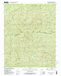
2000 Map of Thunderhead Mtn
USGS Topo · Published 2001About this map
Great Smoky Mountains National Park is defined by its complex network of ridges and high gaps along the Tennessee and North Carolina border. This map documents the wild geography of the high country around Thunderhead Mountain, where the Appalachian Trail follows the state line ridge. This path connects notable high points such as Big Chestnut Bald and Mount Davis, passing through transitions like Beechnut Gap and Mineral Gap. To the north, the headwaters of the Little River and its various prongs descend from the Great Smoky Mountains, while the southern slopes drain into the Hazel Creek and Bone Valley Creek systems. The terrain is marked by distinctive landmarks like Chimney Rocks and Chestnut Flats, illustrating the intricate drainage patterns that have shaped this portion of the Smokies.
Find a feature on this map
62 named features on this map. Tap any name to fly to it.
Don’t see what you’re looking for? This feature index may not catch every label — zoom into the map to look around manually.
Map Details
Editions of this 2000 Thunderhead Mtn Map
This is the sole edition of this map. No revisions or reprints were ever made.
Other maps of this area

1886 · Knoxville
USGS Topo · 1:125,000

1892 · Knoxville
USGS Topo · 1:125,000

1894 · Knoxville
USGS Topo · 1:125,000

1895 · Knoxville
USGS Topo · 1:125,000

1901 · Knoxville
USGS Topo · 1:125,000

1933 · Bushnell
USGS Topo · 1:62,500

1935 · Fontana
USGS Topo · 1:24,000

1936 · Proctor
USGS Topo · 1:24,000
1936 · Gatlinburg
USGS Topo · 1:24,000
1936 · Judson
USGS Topo · 1:24,000