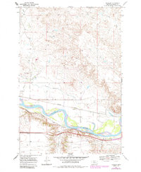
1968 Map of Thurlow
USGS Topo · Published 1985About this map
The Yellowstone River anchors this landscape in Rosebud County, serving as the primary corridor for both transportation and irrigation. The Burlington Northern railroad tracks parallel the river's northern bank, passing through the small station at Thurlow. Agricultural development is visible via the Cartersville Canal, which skirts the valley floor to manage water distribution across the flat bottomlands.
Find a feature on this map
14 named features on this map. Tap any name to fly to it.
Don’t see what you’re looking for? This feature index may not catch every label — zoom into the map to look around manually.
Map Details
Editions of this 1968 Thurlow Map
2 editions found
Other maps of this area

1954 · Forsyth
USGS Topo · 1:250,000

1957 · Forsyth
USGS Topo · 1:250,000

1958 · Forsyth
USGS Topo · 1:250,000

1968 · Rosebud
USGS Topo · 1:24,000

1968 · Box Canyon Coulee
USGS Topo · 1:24,000

1968 · Sand Buttes
USGS Topo · 1:24,000

1968 · Hathaway
USGS Topo · 1:24,000

1968 · Hathaway NW
USGS Topo · 1:24,000

1968 · Thurlow
USGS Topo · 1:24,000
1969 · Miller Creek NW
USGS Topo · 1:24,000