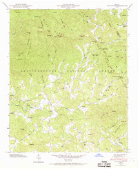
1946 Map of Tickanetley
USGS Topo · Published 1969About this map
The Blue Ridge Divide forms the spine of this landscape in North Georgia, where high-altitude peaks like Rich Mtn Lookout Tower and Tickanetley Bald define the rugged watershed of the Chattahoochee National Forest. Scattered across the valleys are small mountain communities such as Pisgah, Tickanetley, and Marion, many of which were centered around local institutions like Mathis Chapel School and New Liberty Ch. The presence of Stanley Mill on Big Creek and the numerous benchmarks, such as BM HHB 4, suggest a rural economy and landscape being meticulously documented during the mid-twentieth century. Transportation routes wind through steep terrain, crossing gaps like Stover Gap and Hard Slate Gap to connect the river flats of the Cartecay River with the higher elevations of Turniptown Mountain.
Find a feature on this map
75 named features on this map. Tap any name to fly to it.
Don’t see what you’re looking for? This feature index may not catch every label — zoom into the map to look around manually.
Map Details
Editions of this 1946 Tickanetley Map
2 editions found
Other maps of this area

1888 · Ellijay
USGS Topo · 1:125,000

1892 · Ellijay
USGS Topo · 1:125,000

1898 · Ellijay
USGS Topo · 1:125,000

1911 · Ellijay
USGS Topo · 1:125,000

1935 · Noontootla
USGS Topo · 1:24,000
1935 · Cashes Valley
USGS Topo · 1:24,000

1935 · Lake Toccoa
USGS Topo · 1:24,000

1935 · Tickanetley
USGS Topo · 1:24,000
1935 · Wilscot
USGS Topo · 1:24,000
1946 · Tickanetley
USGS Topo · 1:24,000