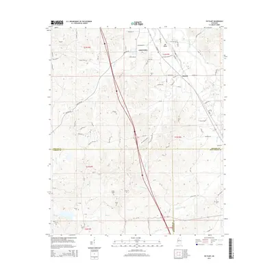
2015 Map of Tie Plant
USGS Topo · Published 2015About this map
Tie Plant and the outskirts of Grenada serve as the primary focal points of this 2015 survey, situated where the borders of Grenada, Carroll, and Montgomery counties converge. This landscape is deeply etched by a network of local waterways, including the winding Batupan Bogue and various creek systems like Perry Cr and Jumping Cr. The settlement pattern is largely defined by its rural connectivity, with a dense concentration of family and community burial grounds that offer significant value for genealogical research.
Find a feature on this map
84 named features on this map. Tap any name to fly to it.
Don’t see what you’re looking for? This feature index may not catch every label — zoom into the map to look around manually.
Map Details
Editions of this 2015 Tie Plant Map
This is the sole edition of this map. No revisions or reprints were ever made.
Other maps of this area

1953 · West Point
USGS Topo · 1:250,000

1954 · Grenada
USGS Topo · 1:62,500

1954 · Duck Hill
USGS Topo · 1:62,500

1954 · McCarley
USGS Topo · 1:62,500

1955 · Coffeeville
USGS Topo · 1:62,500

1958 · West Point
USGS Topo · 1:250,000

1963 · West Point
USGS Topo · 1:250,000
1983 · Tie Plant
USGS Topo · 1:24,000
1983 · Jefferson
USGS Topo · 1:24,000
1983 · Eskridge
USGS Topo · 1:24,000