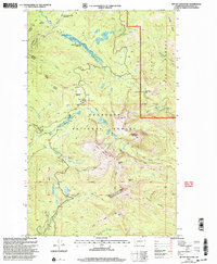
2001 Map of Tiffany Mountain
USGS Topo · Published 2004About this map
Tiffany Mountain and the surrounding high country of the Okanogan National Forest dominate this landscape, which is defined by a dense network of high-elevation trails and alpine basins. The terrain transitions between the national forest and the Loomis State Forest to the east, marked by distinct ridge lines like Timothy Ridge and Freezeout Ridge. This area shows the intersection of wilderness recreation and resource extraction, evidenced by the presence of the Bernhardt Mine along Bernhardt Creek and a Gravel Pit near Three Buttes. The drainage patterns are intricate, with North Fork Salmon Creek and Boulder Creek carving through the granite peaks. High-altitude meadows such as Parachute Meadow and North Twentymile Meadows suggest the seasonal grazing or botanical diversity typical of the eastern Cascades.
Find a feature on this map
52 named features on this map. Tap any name to fly to it.
Don’t see what you’re looking for? This feature index may not catch every label — zoom into the map to look around manually.
Map Details
Editions of this 2001 Tiffany Mountain Map
This is the sole edition of this map. No revisions or reprints were ever made.
Other maps of this area

1906 · Chopaka
USGS Topo · 1:125,000

1954 · Okanogan
USGS Topo · 1:250,000

1955 · Concrete
USGS Topo · 1:250,000

1956 · Tiffany Mountain
USGS Topo · 1:62,500

1956 · Horseshoe Basin
USGS Topo · 1:62,500

1958 · Concrete
USGS Topo · 1:250,000

1958 · Okanogan
USGS Topo · 1:250,000

1962 · Concrete
USGS Topo · 1:250,000

1963 · Doe Mountain
USGS Topo · 1:62,500
1969 · Coleman Peak
USGS Topo · 1:24,000