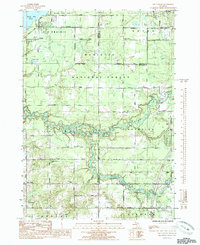
1985 Map of Tift Corner
USGS Topo · Published 1985About this map
Big Prairie and the surrounding woodlands of the Manistee National Forest define this Michigan landscape in the mid-1980s. The map captures a detailed view of the Little Muskegon River as it winds toward the Hardy Dam Pond in the northwest, serving as a focal point for the region's geography and hydrology. For those interested in local genealogy, the area is dotted with small community landmarks, including the Christian Plains Cem and Prairie Cem, along with numerous local houses of worship like Luther Chapel and Pine Grove Chapel.
Find a feature on this map
50 named features on this map. Tap any name to fly to it.
Don’t see what you’re looking for? This feature index may not catch every label — zoom into the map to look around manually.
Map Details
Editions of this 1985 Tift Corner Map
This is the sole edition of this map. No revisions or reprints were ever made.
Other maps of this area

1954 · Midland
USGS Topo · 1:250,000

1958 · Midland
USGS Topo · 1:250,000

1958 · Sand Lake
USGS Topo · 1:62,500

1958 · Woodville
USGS Topo · 1:62,500

1958 · Big Rapids
USGS Topo · 1:62,500

1959 · Midland
USGS Topo · 1:250,000

1959 · Howard City
USGS Topo · 1:62,500

1966 · Midland
USGS Topo · 1:250,000

1976 · Big Rapids SW
USGS Topo · 1:24,000
1976 · Howard City NW
USGS Topo · 1:24,000