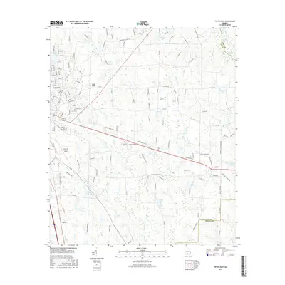
2017 Map of Tifton East
USGS Topo · Published 2017About this map
Tifton serves as the primary urban hub in this South Georgia landscape, where the street grid of its eastern outskirts gives way to a complex network of agricultural lands and wetlands. The drainage of the New River and Gum Cr dominates the central terrain, feeding into numerous named water bodies like Mullis Ponds and Bakers Pond. This 2017 survey highlights the transition from the city's infrastructure, including the Henry Tift Myers Airport, to rural settlements like Vanceville and Brookfield. To the east, the Alapaha River forms a natural boundary, winding through a series of oxbow lakes such as Deserter Lake and Hurricane Lake. The map provides a detailed view of the regional road system and family-named landmarks like Lawrence Cem, which are essential for understanding the local genealogical and land-use history of Tift County during this period.
Find a feature on this map
153 named features on this map. Tap any name to fly to it.
Don’t see what you’re looking for? This feature index may not catch every label — zoom into the map to look around manually.
Map Details
Editions of this 2017 Tifton East Map
This is the sole edition of this map. No revisions or reprints were ever made.
Other maps of this area

1953 · Waycross
USGS Topo · 1:250,000

1958 · Waycross
USGS Topo · 1:250,000

1973 · Ocilla West
USGS Topo · 1:24,000

1973 · Sapps Lake
USGS Topo · 1:24,000

1973 · Waterloo
USGS Topo · 1:24,000

1973 · Enigma
USGS Topo · 1:24,000

1973 · Lenox
USGS Topo · 1:24,000

1973 · Chula
USGS Topo · 1:24,000

1973 · Tifton East
USGS Topo · 1:24,000

1973 · Tifton West
USGS Topo · 1:24,000