
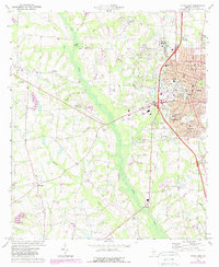
1973 Map of Tifton West
USGS Topo · Published 1976About this map
Tifton serves as the primary urban center for this mid-1970s survey, showing significant growth concentrated east of the Little River. The development patterns here are clearly shaped by the intersection of the Seaboard Coast Line and Southern railroads, which anchor the industrial and residential corridors of Phillipsburg and Unionville. Beyond the city limits, the landscape transitions into agricultural and riparian lands punctuated by local landmarks like the Ty Ty Lookout Tower and the Springhill Country Club.
Find a feature on this map
48 named features on this map. Tap any name to fly to it.
Don’t see what you’re looking for? This feature index may not catch every label — zoom into the map to look around manually.
Map Details
Editions of this 1973 Tifton West Map
2 editions found
Other maps of this area

1953 · Waycross
USGS Topo · 1:250,000

1958 · Waycross
USGS Topo · 1:250,000

1973 · Sumner
USGS Topo · 1:24,000

1973 · Ty Ty
USGS Topo · 1:24,000

1973 · Norman Park
USGS Topo · 1:24,000

1973 · Waterloo
USGS Topo · 1:24,000

1973 · Lenox
USGS Topo · 1:24,000

1973 · Chula
USGS Topo · 1:24,000

1973 · Tifton East
USGS Topo · 1:24,000

1973 · Omega
USGS Topo · 1:24,000