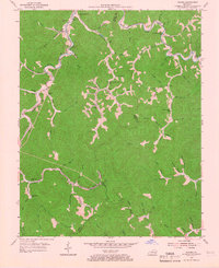
1954 Map of Tilford
USGS Topo · Published 1966About this map
Louisville and Nashville tracks run alongside the winding waters of Leatherwood Creek and Line Fork, marking the industrial lifeline of this mid-century Appalachian landscape. This 1954 field-checked survey reveals a series of small hollow settlements and mining-era communities concentrated near the railroad and local branch waters. Significant local landmarks include rural schoolhouses like Daisy Sch and Holcomb Sch, alongside several mountain churches such as Big Leatherwood Ch and Stony Fork Ch. The terrain is characterized by intricate drainage patterns from Defeated Creek to Little Leatherwood Creek, where the boundary lines of Perry, Letcher, and Harlan counties converge. The map documents the precise location of family-named branches and small settlements like Slemp, Beehive, and Tilford before further decades of change in the eastern Kentucky coalfields.
Find a feature on this map
80 named features on this map. Tap any name to fly to it.
Don’t see what you’re looking for? This feature index may not catch every label — zoom into the map to look around manually.
Map Details
Editions of this 1954 Tilford Map
Other maps of this area

1887 · Jonesville
USGS Topo · 1:125,000

1890 · Whitesburg
USGS Topo · 1:125,000

1891 · Hazard
USGS Topo · 1:125,000

1891 · Jonesville
USGS Topo · 1:125,000

1892 · Whitesburg
USGS Topo · 1:125,000

1894 · Estillville
USGS Topo · 1:125,000

1913 · Oven Fork
USGS Topo · 1:48,000

1915 · Whitesburg
USGS Topo · 1:62,500

1916 · Cornettsville
USGS Topo · 1:62,500

1916 · Nolansburg
USGS Topo · 1:48,000